ARAL (AHR-uhl)
An
inland sea of Central Asia
Common
clues:
Shrinking
Asian body of water; Uzbekistan's ___ Sea; Dying sea of Asia; Sea
east of the Caspian; Asia's ___ Sea; Disappearing sea
Crossword
puzzle frequency:
8 times a year
Frequency
in English language:
61345 / 86800
News: The
Aral Sea from 35,000 Feet: Not a Pretty Picture
Video:
Drying
of the Aral Sea: Timelapse
The Aral Sea is an endorheic inland sea in Central Asia; it lies between Kazakhstan in the north and Karakalpakstan, an autonomous region of Uzbekistan, in the south. Since the 1960s, the Aral Sea has been shrinking, as the rivers that feed it were diverted by the USSR for irrigation. The Aral Sea is badly polluted, largely as the result of weapons testing, industrial projects, and fertilizer runoff before the breakup of the Soviet Union.
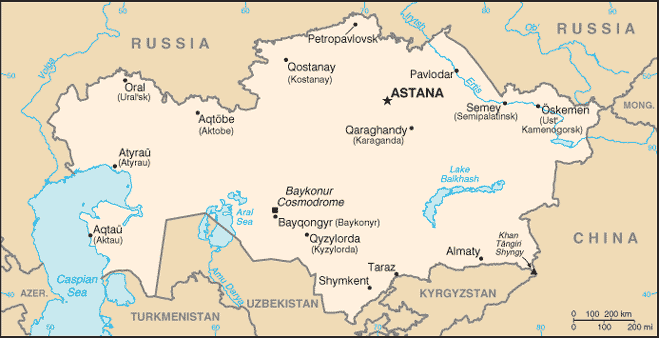
Map
of Kazakhstan (CIA
Factbook)
The major ecological problem is that diversion of the Amu Darya and Syr Darya rivers for irrigation has shrunk the Aral Sea dramatically; the Aral Sea has been drying up for about 40 years. This has brought about a number of ecological problems both for the sea and for the surrounding area.
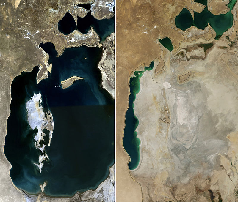
Aral
Sea 1989 (left) 2014 (right)
The Soviet Union decided in 1918 that the two rivers that fed the Aral Sea—the Amu Darya in the south and the Syr Darya in the northeast—would be diverted for irrigating the desert in order to grow rice, melons, cereal, and, above all, cotton; this was part of the Soviet plan for cotton, or "white gold," to become a major export. (This did eventually end up becoming the case, and even today Uzbekistan is one of the world's biggest exporters of cotton.)
The sea's surface area has now shrunk by approximately 60 percent, and its volume by almost 80 percent. Over the same time period, the salinity of the Aral Sea has increased from about 10 g/l to about 45 g/l.
The ecosystem of the Aral Sea and the river deltas feeding into it has been nearly destroyed, not least because of the much higher salinity. The land around the Aral Sea is also heavily polluted, and the people living in the area are suffering from a lack of fresh water, as well as from a number of other health problems—the receding sea has left huge plains covered with salt and toxic chemicals, which are picked up, carried away by the wind as toxic dust, and spread to the surrounding area; the population around the Aral Sea now shows high rates of certain forms of cancer and lung diseases, as well as other diseases. Crops in the region are also destroyed by salt being deposited onto the land. The town of Moynaq in Uzbekistan had at one point a thriving harbor and fishing industry employing approximately 60,000 people; now the town lies miles from the shore. Fishing boats lie scattered on dry land that was once covered by water; many of them have been there for 20 years.
Work is being done to restore in part the North Aral Sea. Irrigation works on the Syr Darya have been repaired and improved to increase its water flow, and in October 2003, the Kazakh government announced a plan to build Dike Kokaral, a concrete dam separating the two halves of the Aral Sea. Work on this dam was completed in August 2005; since then, the water level of the North Aral has risen, and its salinity has decreased. As of 2006, some recovery of sea level has been recorded, sooner than expected. "The dam has caused the small Aral's sea level to rise swiftly to 38 m (125 ft), from a low of less than 30 m (98 ft), with 42 m (138 ft) considered the level of viability."
Economically significant stocks of fish have returned, and observers who had written off the North Aral Sea as an environmental disaster were surprised by unexpected reports that, in 2006, its returning waters were already partly reviving the fishing industry and producing catches for export as far as Ukraine. The restoration reportedly gave rise to long-absent rain clouds and possible microclimate changes, bringing tentative hope to an agricultural sector swallowed by a regional dustbowl, and some expansion of the shrunken sea.
"The sea, which had receded almost 100 km (62 mi) south of the port-city of Aralsk, is now a mere 25 km (16 mi) away." The Kazakh Foreign Ministry stated that "The North Aral Sea's surface increased from 2,550 square kilometers (980 sq mi) in 2003 to 3,300 square kilometers (1,300 sq mi) in 2008. The sea's depth increased from 30 meters (98 ft) in 2003 to 42 meters (138 ft) in 2008."[1] Now, a second dam is to be built based on a World Bank loan to Kazakhstan, with the start of construction initially slated for 2009 and postponed to 2011, to further expand the shrunken Northern Aral, eventually reducing the distance to Aralsk to only 6 km (3.7 mi). Then, it was planned to build a canal spanning the last 6 km, to reconnect the withered former port of Aralsk with the sea.
This article is licensed under the GNU Free Documentation License (http://www.gnu.org/copyleft/fdl.html). It uses material from the http://en.wikipedia.org/wiki/Aral_Sea.
|
|